Brenda and I spent 2 weeks or so flying across the country to Asheville, North Carolina to spend the holidays with my family. Actual flying time was 38.7 hours over 6 days, three out and three back. We also spent a day or two in Memphis, Tennessee hanging out with Elvis. Here's my pilot-geeky account of the trip. You can also check out out our blog for a more balanced account.
There are more pictures of the trip.
Day One (18 Dec)
Santa Monica (SMO) to Prescott, AZ (PRC)
 The trip started off with a beautiful VFR
day, with the winds unusually from inland. Though we got off a little
late, we had a solid tailwind all day, which helped make up some time.
We departed runway 3 for Prescott climbing up to 9,500 and out through
the Banning Pass. Somewhere out near Palm Springs, Brenda nodded off.
The trip started off with a beautiful VFR
day, with the winds unusually from inland. Though we got off a little
late, we had a solid tailwind all day, which helped make up some time.
We departed runway 3 for Prescott climbing up to 9,500 and out through
the Banning Pass. Somewhere out near Palm Springs, Brenda nodded off.
The terrain beyond Palm Springs started rising into the mountainous terrain I was expecting out in Arizona and New Mexico. This part of the route showed us the first of out large, state-named rivers as we crossed the Colorado River near Parker, AZ. We also had a treat passing the Bagdad Airport, though Bagdad, AZ is considerably smaller and safer than its Middle East namesake.
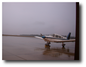
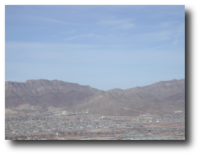
Soon enough we skirted Granite Mountain and landed at Prescott where the fine folks at the terminal filled 32169 up while we filled up at the restaurant. The food was good and the restaurant warm and inviting. The field was small, but clearly served a broad range of the community with both scheduled air service and classic biplanes in evidence.
Prescott, AZ (PRC) to Santa Fe, NM (SAF)
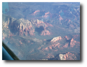
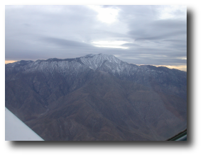
This was my favorite leg of the trip as far as scenery goes. Every checkpoint brought another fantastic sight, like the terrain pictured here near Sedona, AZ. We also flew over a meteor crater of unbelievable scale, countless buttes with snow in their shadows and landscapes that are more believable on Mars than Earth. Tempted as I was to believe that there was no terrain more exciting, we were also teased by the south edge of the Painted Desert. It was difficult not to just divert north and see what else the wind and tectonics had prepared for me. Along the way we also passed Winslow, Arizona which I'd only ever considered as an Eagles's lyric. There are a variety of pictures from this leg in the album, and I recommend checking them out.
 This was also the leg that made me the most jumpy during flight
planning. For a guy who spends most of his time flying in the LA basin,
this area of the Albuquerque sectional
is awfully brown and orange without a lot of airports on it. While
looking at the map, I was plenty concerned about where I might put down
if I had an engine failure. I was pleasantly surprised. While I
wouldn't say that the terrain was inviting, there were more options than
I expected. Adding to that the fact that we'd packed supplies and
sleeping bags in case of trouble, and I felt reasonably prepared for a
bad situation. Even better, none developed.
This was also the leg that made me the most jumpy during flight
planning. For a guy who spends most of his time flying in the LA basin,
this area of the Albuquerque sectional
is awfully brown and orange without a lot of airports on it. While
looking at the map, I was plenty concerned about where I might put down
if I had an engine failure. I was pleasantly surprised. While I
wouldn't say that the terrain was inviting, there were more options than
I expected. Adding to that the fact that we'd packed supplies and
sleeping bags in case of trouble, and I felt reasonably prepared for a
bad situation. Even better, none developed.
After 3 hours or so, SAF came into view and we settled in for a briefing and break at the Million Air there. They took fine care of us, and got us on our way quickly and safely as the sun was setting. Flying east seems to help you with the wind, but hurt you with less daylight.
Santa Fe, NM (SAF) to Amarillo, TX (TDW)
This was a short night leg to Amarillo. As usual, I filed IFR because it was night. I was especially happy to be IFR because we were still in high terrain that I didn't know. In fact, I turned down a shorter clearance that required managing my own terrain clearance. It was a clear calm night, and the trip was an easy one. Obviously there weren't many sights to see in the dark far from Roswell.
 Because we were lower, Brenda was much more lively on this leg, and got
some cool pictures of the flight deck while the sun was setting. They
look like a submarine in general quarters, and are super neat. See them
at the blog.
Because we were lower, Brenda was much more lively on this leg, and got
some cool pictures of the flight deck while the sun was setting. They
look like a submarine in general quarters, and are super neat. See them
at the blog.
We followed a Cessna into TDW, and made my worst landing of the trip, by far. I let things get slow on approach and rather than go around, I decided to save the landing. The result was a very flat landing that was certainly nothing to write home about. A good reminder to go around rather than save it. Then, as usual when I arrive at an uncontrolled field at night, I taxied aimlessly until I found the FBO. We're still hoping to find a cure for this. Your contribution could make the difference.
The nice folks at TDW took good care of us, got us squared away with fuel and connected us with our hotel. Sadly the only place we could find to eat was a Denny's. It wasn't a horrible Denny's, but there's only so good that they get. Probably our worst meal of the trip.
Day 2 (19 Dec)
Amarillo, TX (TDW) to Fort Smith, AR (FSM)
Let me tell you: it gets cold in the Texas panhandle in the winter.
Brenda and I accidentally slept late, but it was still right around
freezing when we arrived at Tradewind for our departure. We weren't the
only ones half awake, though, as the airline pilot we shared a shuttle
with was pretty confused to find that Tradewind wasn't the main terminal
of AMA.
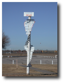
It doesn't often get that cold around Santa Monica, so I was a little concerned about starting, though fortunately a thorough pre-flight showed no frost on the plane. I asked a little advice from one of the local pilots about a pre-heat. He seemed to think things would start up OK, and it wasn't super clear where I might get a pre-heat. I primed a little more than usual and started up. This worked out pretty well, but I let her idle a long time while I took my time getting charts and equipment ready to go. With the heater on. The nice folks who own TDW were kind enough to provide the sign here to help me with flight planning.
In addition to being good at cold, the Texas panhandle also does a fine job of being flat. This is the area of the country that Stephen Coonts immortalized in the October 2003 AOPA Pilot. On the strength of his experience, I strongly considered diverting to Pampa, TX, but decided I'd rather reach my planned stop in Memphis, instead.
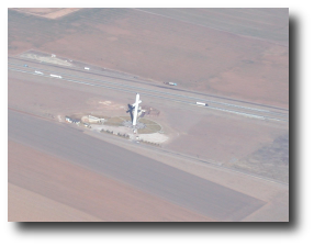 As I say, it's flat. But the folks in Texas apparently know how to keep
busy. Outside of Groom, TX, we spotted the largest cross in the Western
hemisphere, pictured here. It's 19 stories high, so on a clear, cold
day in Texas it's quite striking, even from a mile up. Yes, those blobs
on the road are semi trucks, just for scale. I hadn't realized that
we'd be flying over it, but I'd heard about it on
the 21 Dec 2001 broadcast of This American Life. One
look was all it took to realize that this must be the one that Ira Glass
and the boys had told me about.
As I say, it's flat. But the folks in Texas apparently know how to keep
busy. Outside of Groom, TX, we spotted the largest cross in the Western
hemisphere, pictured here. It's 19 stories high, so on a clear, cold
day in Texas it's quite striking, even from a mile up. Yes, those blobs
on the road are semi trucks, just for scale. I hadn't realized that
we'd be flying over it, but I'd heard about it on
the 21 Dec 2001 broadcast of This American Life. One
look was all it took to realize that this must be the one that Ira Glass
and the boys had told me about.
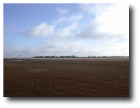
We pedaled on past a lot of small towns, covering the width of Oklahoma, and settled into Fort Smith Regional Airport. Not my finest pattern ever, but an acceptable touchdown. FSM was good and busy with F-16 crews zipping in and out. TacAir let us have a courtesy car for lunch, and we discovered a great family restaurant called Calico County. You know you're in for an artery-stopping event when you find chicken fried chicken on the menu. As good as everything was, really the onion rings were the high point. Outstanding.
Fort Smith, AR (FSM) to Millington, TN (NQA)
After returning the courtesy car and being awed by the F-16 climbouts, I filed IFR to Millington, just north of Memphis. We were running late from sleeping in, and with the winter solstice a couple days away and timezone crossings not in our favor, a night landing in Millington was likely. At night it's nice to have an ILS as an option.
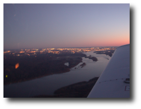 The trip out to NQA was a clear, pleasant, fast one. We had a good 30
knots of tailwind, and I saw airspeeds in excess of 150 kts a couple
times. I could pretend I owned a Mooney for a while. At any rate, we
crossed the rest of Arkansas, overflying the Mississippi River as dusk
settled in. I did get the ILS into NQA, and we taxied off the runway
with instructions to pull up to the FBO
(Tulsair)
tightly enough that the F-14 could taxi behind us. There's a naval base
at Millington, and apparently they fly F-14 missions out of there.
Watching the Tomcat taxi past as we unloaded was like being on the deck
of the carrier in Top Gun. Well without all the urgency, anyway. A
very cool experience.
The trip out to NQA was a clear, pleasant, fast one. We had a good 30
knots of tailwind, and I saw airspeeds in excess of 150 kts a couple
times. I could pretend I owned a Mooney for a while. At any rate, we
crossed the rest of Arkansas, overflying the Mississippi River as dusk
settled in. I did get the ILS into NQA, and we taxied off the runway
with instructions to pull up to the FBO
(Tulsair)
tightly enough that the F-14 could taxi behind us. There's a naval base
at Millington, and apparently they fly F-14 missions out of there.
Watching the Tomcat taxi past as we unloaded was like being on the deck
of the carrier in Top Gun. Well without all the urgency, anyway. A
very cool experience.
It took a few minutes to get our rental car, as the FBO was pretty busy getting a charter unloaded and getting a few other Tomcat pilots underway. After a few minutes, we did get the car, and not having an airport to taxi aimlessly about, I taxied the rental car aimlessly around Millington until we found our hotel.
Memphis
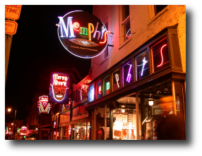 Memphis is a great city to bum around for a couple days, and we did just
that. This was a planned stop.
Memphis is a great city to bum around for a couple days, and we did just
that. This was a planned stop.
The blog can tell you more about the stop, but we had ribs at Rendez-Vous, toured Graceland and Sun Studios, and watched the procession of the Peabody Ducks to their fountain. Despite the fact that she's vegetarian, Brenda said Rendez-Vous was one of the best meals of the trip. Apparently their meatless red beans and rice are to die for. We really didn't get to do Beale Street properly, and missed a few other attractions, but had a great relaxing visit.
Day 3
Millington, TN (NQA) to Chattanooga, TN (CHA)
After seeing the ducks off at the Peabody, we departed Millington for Chattanooga. Again, the weather was gorgeous, and we had a pleasant, easy VFR trip.
 While Tennessee doesn't have the breathtaking scenery that we saw in
Arizona and New Mexico, the countryside is beautiful. There are lots
of rolling hills and forests, dotted with lakes and rivers. It's more
of a comfortable, inviting landscape.
While Tennessee doesn't have the breathtaking scenery that we saw in
Arizona and New Mexico, the countryside is beautiful. There are lots
of rolling hills and forests, dotted with lakes and rivers. It's more
of a comfortable, inviting landscape.
This leg also treated us, well me really, to the most abstract landmark of the trip. Western Tennessee is crossed by the zero degree isogonic line. Along this line magnetic north, as shown by a compass, and true north, the direction to the Earth's rotation nearest the north magnetic pole, are the same. Unless you're a pilot or mariner, this is pretty irrelevant and boring. Even if you are one, it may be irrelevant and boring, but I got a kick out of crossing it.
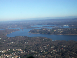
Fairly quickly, we crossed the Tennessee River (pictured) and found ourselves at Chattanooga's Lovell Field.
Chattanooga, TN (CHA) to Asheville, NC (AVL)
The homestretch. Again, though it was still light when we departed, it was easy to see that we were going to have a night landing in Asheville, so again I filed IFR on a clear day. Departing CHA we were cleared “direct Choo-Choo” (one of the VORs near Chattanooga is called choo-choo), which was really worth all the hassle of filing right there. Sarah Vowell fans know what I mean.
This was a short flight in the beautiful clear air, with the sun slowly setting behind us. The bulk was over the Smoky and Blue Ridge Mountains. Like the terrain in Arizona and New Mexico, it's not as inhospitable to an emergency as I feared it might be (though I thankfully didn't get to test that). However, for conventional travel, it's good and isolated. One could get lost pretty well there, intentionally or not.
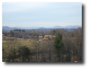
The sun was well set by the time we reached Asheville, and one of the most friendly and helpful tower/approach controllers I've ever encountered eased us in on a visual approach.
My parents were there to greet us, load our luggage up and take us out to dinner. A good way to start the holiday week.
Asheville, NC
Asheville is a small town nestled up in the Blue Ridge Mountains, near the Tennessee border. The setting is beautiful. The town itself is an interesting mix of old time residents, retirees drawn by the relaxed pace of life, and young people drawn by the local colleges which have particularly strong environmental programs. The result is a lively place but a stable one.
 The point of the trip was to spend the holidays with my family out in
Asheville, and spending time with them was great fun. My brother
brought his new sweet baby down (or she brought him) and with my sister
already living there the family was all together for the first time in a
couple years. We saw my sister's house for the first time, hung out
with my parents, installed a quilting table, baked Christmas cookies and
exchanged gifts. We also visited the
Biltmore House for a night tour,
had lunch at the Grove Park Inn,
and visited the
North Carolina Arboretum.
It was a fun and relaxing holiday season.
The point of the trip was to spend the holidays with my family out in
Asheville, and spending time with them was great fun. My brother
brought his new sweet baby down (or she brought him) and with my sister
already living there the family was all together for the first time in a
couple years. We saw my sister's house for the first time, hung out
with my parents, installed a quilting table, baked Christmas cookies and
exchanged gifts. We also visited the
Biltmore House for a night tour,
had lunch at the Grove Park Inn,
and visited the
North Carolina Arboretum.
It was a fun and relaxing holiday season.
More pictures of holiday merriment are available in the album and our blog.
Day 4
Asheville, NC (AVL) to Birmingham, AL (BHM)
This was the most challenging flying day we had. There was a cold front moving across the middle of the country, but doing it slowly, and indications that a second storm would be along through Arizona and New Mexico, dumping snow in the north and central regions in a day or two. To avoid the following storm, I planned a more southerly route than the one we took out, but there wasn't much to do about the front except keep tabs on it for convective activity or icing and divert or deal when it comes. As there was little convection reported, I tentatively planned to stop in Abilene, TX after a long day and crossing the front.
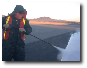 Asheville threw me another curve that morning – frost on the
wings. Now, if you're not a pilot, you may well be saying “so
what, a little frost is no big deal.” Sadly, it can be. Even
though frost is only a fingernail thick, its rough surface can cause
airflow around the wings to separate from the contours of the wings
early. The result can be a loss of 50% or more of a wing's ability to
produce lift. As a flyer I'm very fond of lift, and like to have my
full complement of it available at all times. The solution is to either
polish it smooth or get it off the wings. Flying in Southern
California, I don't have a lot of experience with either, but the fine
folks at Million Air (the local FBO)
had another option: a deicing. How could I say no to a deicing? (I did
check the price, which seemed reasonable, especially compared to
removing the stuff myself in 23°F.) Deicing consists mainly of
spraying high pressure ethelyne glycol on the various surfaces of the
plane. Between the pressure and the low freezing point of the glycol,
ice and frost is melted (because the solution that results has a low
freezing point) or simply knocked right off. The residual glycol has a
mild deterrent value if there's ice encountered airborne, but not enough
to rely on.
Asheville threw me another curve that morning – frost on the
wings. Now, if you're not a pilot, you may well be saying “so
what, a little frost is no big deal.” Sadly, it can be. Even
though frost is only a fingernail thick, its rough surface can cause
airflow around the wings to separate from the contours of the wings
early. The result can be a loss of 50% or more of a wing's ability to
produce lift. As a flyer I'm very fond of lift, and like to have my
full complement of it available at all times. The solution is to either
polish it smooth or get it off the wings. Flying in Southern
California, I don't have a lot of experience with either, but the fine
folks at Million Air (the local FBO)
had another option: a deicing. How could I say no to a deicing? (I did
check the price, which seemed reasonable, especially compared to
removing the stuff myself in 23°F.) Deicing consists mainly of
spraying high pressure ethelyne glycol on the various surfaces of the
plane. Between the pressure and the low freezing point of the glycol,
ice and frost is melted (because the solution that results has a low
freezing point) or simply knocked right off. The residual glycol has a
mild deterrent value if there's ice encountered airborne, but not enough
to rely on.
 Pre-flighting in 23°F was not much fun, either. I need to own some
cold weather gear before the next time I tromp off into places it gets
that cold. In general, the plane weathered it better than me, but the
flaps were sticky. They were sticking down, which is where I
want 'em if I put 'em down, but it wasn't great to see. Although they
could deice me, the pre-heater was unavailable, so I was going to have
to start the engine cold. It didn't seem happy about this, but
complied, and the heater was working quickly, too.
Pre-flighting in 23°F was not much fun, either. I need to own some
cold weather gear before the next time I tromp off into places it gets
that cold. In general, the plane weathered it better than me, but the
flaps were sticky. They were sticking down, which is where I
want 'em if I put 'em down, but it wasn't great to see. Although they
could deice me, the pre-heater was unavailable, so I was going to have
to start the engine cold. It didn't seem happy about this, but
complied, and the heater was working quickly, too.
After the deicing, we were off to Birmingham. Despite the clear conditions, I filed IFR. Compared to the route I'd planned out, I really hadn't spent a lot of time planning this one, so better to follow the airways. If I'm flying an IFR route, no sense not being under IFR. I can always cancel.
The scenery was nice enough, once we were warm enough to enjoy it, but this leg introduced us to the headwind that we'd become familiar with throughout the next 3 days. We were definitely paying for the high groundspeeds coming out by crawling back at speeds often less than 100 kts. We landed at Birmingham to find temperatures improved by 30-35 degrees, and were much happier campers. The flaps were unstuck, too.
Birmingham, AL (BHM) to Texarkana, AR (TXK)
A call to flight service confirmed that the front was continuing to crawl toward Texarkana, our next stop, and so rather than give the front time to sock TXK in, we got snacks, filed IFR and headed out.
 Actually there was one more thing to do in BHM. The
FBO there,
Mercury Air, had overcharged
us for gas. Fortunately, they caught the error before we left
(probably based on my concern about fuel use - it was a very careful
pre-flight before we left). In any case, it was good to see that kind
of conscientious service.
Actually there was one more thing to do in BHM. The
FBO there,
Mercury Air, had overcharged
us for gas. Fortunately, they caught the error before we left
(probably based on my concern about fuel use - it was a very careful
pre-flight before we left). In any case, it was good to see that kind
of conscientious service.
So, off we go into a projected growing bank of clouds and rain. The mountains begin to flatten into the great plains and the clouds start to gather. We did pass through a couple banks of fair weather cumulus fairly far ahead of the front, which are always fun to fly through. It's kind of like flying through a big canyon, except that there's no danger of hitting a wall.
Those canyon cumulus clouds are probably my second favorite kind of clouds, with a flat deck right at my altitude being my favorite. The flat deck gives you a great feeling of sustained speed. In any case, we were in and out of the “canyons” quickly.
Less fun was the steady headwind we were pushing against. I considered going up higher, but the forecast seemed to indicate that the additional speed gains from higher flight would be traded off against increased wind. Bleah. I kept a close watch on the fuel reserves and the conditions at TXK and continued on. At least if we diverted I'd have a tailwind.
 Canyon clouds were replaced by a building undercast that engulfed us
40 miles outside Texarkana. At this point I was pretty confident that
fuel wasn't a factor and that we should be able to land easily in the
reported conditions. After about a half an hour of maneuvering in the
clouds (no, ice – thanks for asking), briefing the approach and
setting up the avionics, we popped back out of the clouds at
glideslope intercept on the
ILS. I flew the needles down to the
ground, because visibility wasn't great and it's a good idea
anyway. Still, conditions were too good for me to log the approach with
a clear conscience. The landing was pretty straightforward.
Canyon clouds were replaced by a building undercast that engulfed us
40 miles outside Texarkana. At this point I was pretty confident that
fuel wasn't a factor and that we should be able to land easily in the
reported conditions. After about a half an hour of maneuvering in the
clouds (no, ice – thanks for asking), briefing the approach and
setting up the avionics, we popped back out of the clouds at
glideslope intercept on the
ILS. I flew the needles down to the
ground, because visibility wasn't great and it's a good idea
anyway. Still, conditions were too good for me to log the approach with
a clear conscience. The landing was pretty straightforward.
After we got tucked into TacAir, the rain really started behind us. I was hopeful that the front might pass through quickly and let us take a night flight to Abilene. We borrowed their courtesy car for a meal. I'd like to tell you that this was a great feed, but no such luck. We basically wound up at a chain mexican place and had mediocre food.
It was still raining when we got back, and a call to flight service confirmed that the front was only moving slowly through the area, and that there was some possible convection to the west. It seemed reasonably possible to skirt the thing, but I'd already flown more than 6 hours, night was falling, 32169 doesn't have any on-line weather, and I was unfamiliar with the area. I didn't have to be in Abilene that badly, thanks. We canceled our reservations in Abilene (which seemed to make the hotel people genuinely sad) and made some new ones in beautiful Texarkana. We took a cab to the motel that had a dome light that would occasionally fill with enough water through the roof to create a small waterfall on the front passenger seat. Thankfully we were in back.
Day 5
Texarkana, AR (TXK) to Abilene, TX (ABI)
 Morning dawned cool but clearing in Texarkana. The front had moved on
in the night, leaving clearing weather in town and clear weather to the
west along the rest of our route. Unlike Asheville, it hadn't cooled
enough to freeze. The overcast was just burning off, so
I filed IFR, but by the time we made
our actual takeoff we didn't encounter any clouds.
Morning dawned cool but clearing in Texarkana. The front had moved on
in the night, leaving clearing weather in town and clear weather to the
west along the rest of our route. Unlike Asheville, it hadn't cooled
enough to freeze. The overcast was just burning off, so
I filed IFR, but by the time we made
our actual takeoff we didn't encounter any clouds.
The flight was clear and uneventful to Abilene, though those same headwinds kept us on our toes. They were almost exclusively west to east winds, so we actually got some relief when we turned south around the Dallas/Fort Worth Class B airspace. Even better, we got a helpful early turn that got us off the due westerly course early.
ATC was uniformly professional and helpful throughout the trip, though I remember one Fort Worth controller because he clearly had a Chinese accent. He was easy to understand, and helpful and professional, but the difference between his Chinese-accented perfect grammar and the rest of the noticeably southern-born controllers was kind of jarring. Especially over Texas.
 The land flattened out, with lakes appearing around the Dallas area,
then disappearing as we moved further west. Abilene came into sight,
and we executed a simple visual approach. American Eagle seems to have
a maintenance or mothballing facility here, because there were a bunch
of Eagle Saabs parked at the airport.
The land flattened out, with lakes appearing around the Dallas area,
then disappearing as we moved further west. Abilene came into sight,
and we executed a simple visual approach. American Eagle seems to have
a maintenance or mothballing facility here, because there were a bunch
of Eagle Saabs parked at the airport.
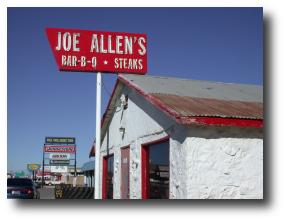
Really the highlight of the Abilene stop wasn't the airport, but the food. The nice folks at Abilene Aero were good enough to send us to Joe Allen's for BBQ. This was a classic BBQ joint, with the picnic tables, self service, and fantastic amounts of well cooked meat. How Brenda got talked in to this, I'll never know. If you're in Abilene and like this sort of thing, look 'em up. And check out the interior shots in the album, too.
Abilene, TX (ABI) to El Paso, TX (ELP)
Somehow we pulled me from Joe Allen's and got back underway. This time IFR to El Paso. We knew we were only doing the 2 legs today, so we'd left Texarkana later, avoiding the morning cold. This meant that the trip to El Paso would finish up later and we'd be arriving at night. Again, unfamiliar high terrain at night sounded like a good recipe for IFR.
 If you need a synonym for “desolate,” “West
Texas” will do nicely. It's a splendid desolation, though –
full of wide spaces and strangely beautiful terrain. Wind and weather
didn't have as many huge outcroppings to have their way with here as
they did in Arizona and New Mexico, but the forces of nature seem to
have shown enough creativity to bridge the gap. There's no question
that it's got an attraction to it, but it's so deserted that you want to
have supplies if you're flying over it at night. The gallons of
emergency water were comforting between Abilene and El Paso. Prevailing
headwinds gave us plenty of time to consider these things.
If you need a synonym for “desolate,” “West
Texas” will do nicely. It's a splendid desolation, though –
full of wide spaces and strangely beautiful terrain. Wind and weather
didn't have as many huge outcroppings to have their way with here as
they did in Arizona and New Mexico, but the forces of nature seem to
have shown enough creativity to bridge the gap. There's no question
that it's got an attraction to it, but it's so deserted that you want to
have supplies if you're flying over it at night. The gallons of
emergency water were comforting between Abilene and El Paso. Prevailing
headwinds gave us plenty of time to consider these things.
We arrived in El Paso as night fell, and took a long, straight visual approach. It was one of my better, more stabilized landings for the trip, and Brenda took some interesting pictures of it. We tied down, signed in at the FBO and shuffled off to the same hotel where the media was staying for the Sun Bowl. Dinner at Appleby's was something of a disappointment after Joe Allen's.
Day 6
El Paso, TX (ELP) to Tuscon, AZ (RYN)
I think I've mentioned how cold the desert gets at night once or twice, but El Paso was happy to reinforce this lesson for us. Fortunately it was also bone dry, with a dewpoint in the negative teens Celsius, so no frost. Still, I got to experience a 28°F pre-flight, which isn't noticeably more fun than the 23°F one in Asheville. Yes, the flaps stuck again. No, I didn't have a pre-heater available here, either.
Though it was cold on the ground, the good news was that the projected storms had passed to the north, so there were nothing but blue skies forecast until the LA basin. And the forecast for clouds in LA would prove to be wrong, too.
 Unless I'm misreading my GPS, departure took us a bit across the Mexican
border, but we were IFR, so no worries.
Unless I'm misreading my GPS, departure took us a bit across the Mexican
border, but we were IFR, so no worries.
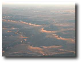
Southern New Mexico and Arizona are desolate, too. There were a few interesting things to see, though. Among the man-made sights were a tethered weather balloon up around 9-10 thousand feet and a set of greenhouses tens of miles from anywhere. Nature supplied some fantastic rock formations including Cochise Head and Dos Cabesas. There was still enough sparsely inhabited or uninhabited land between these to make me happy about the emergency supplies in the back.
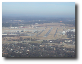
As we crossed Tuscon, I learned that no matter what aviation tool you might need (in terms of aircraft), Davis Mothan AFB has it. Acres of aircraft of every imaginable shape and size are available here for the defense of the West.
Our destination, Ryan Field, was less well equipped, but a perfectly delightful field for our needs. There was a steady buzz of traffic, mostly from students, and a really excellent little restaurant. It was cozy and informal, but had a number of unusual dishes incorporating local ingredients, notably prickly pear. Well worth a visit.
Tuscon, AZ (RYN) to Blythe, CA (BLH)
As we got close to home, and the weather was gorgeous, I went back to VFR flying. This was a VFR leg, up to Blythe, which is just on the California side of the Colorado River. Good visibility and easy terrain and flying weather made this a smooth leg. Better still, the strong head winds were abating.
 Passing through the airspace near Gila Bend AFB I got to hear some crack
ATC routing military jets out and about.
It was the kind of precise, rapid-fire communications that put a pilot
on his or her best behavior, and I strived to be on mine. Of course I
only had to check on and check off, basically, but I tried to do so
correctly.
Passing through the airspace near Gila Bend AFB I got to hear some crack
ATC routing military jets out and about.
It was the kind of precise, rapid-fire communications that put a pilot
on his or her best behavior, and I strived to be on mine. Of course I
only had to check on and check off, basically, but I tried to do so
correctly.
Blythe Airport was nearly deserted when we came through. A small uncontrolled field on the outskirts of a small farming community on the Colorado River, it's not often a hotbed of activity. Today it was just us and the fellow who pumped the gas at Wolfe Aviation. He pumped the gas, settled up and went back off to work on a car or plane (I couldn't tell which vehicle was getting the attention and which was a conversation prop) in the hangar. He wasn't unfriendly, and the service was great, but I don't think we were the high point of his day.
Blythe, CA (BLH) to Santa Monica, CA (SMO)
As we climbed out of Blythe, it was hard to believe that we'd reached our last leg. Though early forecasts had been for the LA basin to be clouded over, this hadn't materialized, and conditions were good VFR. I was looking forward to familiar terrain.
 I never cease to be impressed by the professionalism of
ATC. As we started the leg back to SMO,
some fellow in a business jet was trying to get himself a pretty
unreasonable clearance from ATC clearly for the convenience of himself
or his passengers. There was plenty of military training going on, and
this guy figured he could just cut right across it all to make a
deadline that he had. On top of that, he wanted to tell the controller
how to do his job. Now, I won't say that the controller was sweet and
nice to the guy, but he was professional at all times. And he also
helped another fellow avoid a restricted area, and rerouted a plane with
a pressurization problem more directly. Good guys working under tough
conditions.
I never cease to be impressed by the professionalism of
ATC. As we started the leg back to SMO,
some fellow in a business jet was trying to get himself a pretty
unreasonable clearance from ATC clearly for the convenience of himself
or his passengers. There was plenty of military training going on, and
this guy figured he could just cut right across it all to make a
deadline that he had. On top of that, he wanted to tell the controller
how to do his job. Now, I won't say that the controller was sweet and
nice to the guy, but he was professional at all times. And he also
helped another fellow avoid a restricted area, and rerouted a plane with
a pressurization problem more directly. Good guys working under tough
conditions.
Soon we had come to Palm Springs, then through the Banning Pass to the familiar airspace of the LA basin. I was very happy to be able to tell what things were without referring to the chart. The trip through the basin was uneventful, other than an unusual runway 3 landing at SMO. Oddly, we'd taken off runway 3 to start this expedition. We landed, met Brenda's mom at the Spitfire Grill and headed home to have dinner with her dad to celebrate his birthday. It's all one big party with us.